Official visual estimates and official Parliamentary Amendment to the Bill circulated
SANDY POINT, St. Kitts and Nevis, October 12th, 2012 -- Ahead of a meeting with Dr. Timothy Harris MP, Minister of Agriculture and of Constituency Empowerment, the Sandy Point consortium of civil society organizations has released official visual estimates of the amount of land earmarked by the recent St. Kitts-Nevis-Anguilla National Bank (Vesting of Certain Lands) Bill 2012.
The group which comprises Sandy Pointers Inspiring Real Improvement Throughout (SPIRIT), Sandy Point Agricultural Cooperative Society (SPACS) and Community Improvement and Personal Empowerment Organization (CIPEO), have held talks in the past week with three consultants in the areas of Planning and Sustainable Development, Land Use Policy and Agriculture and Environmental Protection. And, these meetings produced a near-accurate representation of the acreage of land swapped by the effect of the Bill and the groups have issued for the first time the official Parliamentary Amendments to the Bill which illustrate the areas in which the lands can be located.
SPIRIT President Seanel Riley notes the importance of such visual aids.
‘’We continue to run a very measured but deliberate campaign, highlighting two main points: the importance of land ownership and access to land in any discussion on community development which necessitates our second main call—the need for consultations with the community on matters of such importance. We believe that if people can get a visual idea of just how much land is being swapped, they will be energized to join our campaign,’’ Riley said.
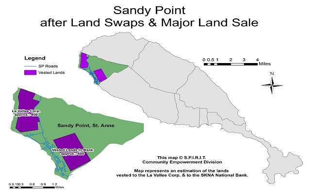
The groups have together released four pictures generated by Google Earth mapping software highlighting the areas affected by the 2012 Bill, and one further aerial map of the area produced by SPIRIT’s Community Empowerment Division also shows the lands under ownership under the La Valle project. According to CIPEO President Stephen Duggins, these pictures together with the guidelines in the Bill’s Amendment are helpful to visualize the huge impact the Act will have on the Sandy Point area.
"The maps may not be located exactly but it is only meant to illustrate the actual size (appr. 500 acres) of the land in comparison to the overall size of Sandy Point. It really does run the length of the town! This is rather devastating! It is as if our Government and Parliament have just evicted a whole community,’’ Duggins said.
The groups noted that they expect the meeting with Dr. Harris MP to place their disapproval on record, to secure key assurances from his Ministry and to discuss possible ways forward in respect of Sandy Point’s lands and other major areas of interest to the people of Sandy Point.
ST KITTS-ANGUILLA NATIONAL BANK LIMITED(VESTING OF CERTAIN LANDS) BILL, 2012
Proposed Amendments
It is proposed to amend the St. Kitts-Nevis-Anguilla National Bank Limited Bill, 2012, as follows:
1. In Clause 3, replace the words 'to be specified in Order made by the Minister" with the words ", which is specified in the Schedule to this Act,".
2. Replace Clause 4 with the following new Clause: "4. Amendment to the Schedule.
The Minister may, by Order, amend the Schedule to this Act.".
3. Insert at the end of the Bill the following Schedule:
"SCHEDULE
PART I
600 ACRES - GENERAL DESCRIPTION OF LANDS
Sir Gillies Estate, Farms Estate & Bourkes Estate - 497.17 Acres
Parcel 1
On or towards the north by ghaut approximately 900 ft;
On or towards the east by Estate Road approximately 700 ft
On or towards the northeast by Estate Road leading to Sir Gillies Estate Yard
approximately 500 ft;
On or towards the south by Estate Road to Sir Gillies Estate Yard 500 ft;
On or towards the west partially by the Island Main Road approximately
600 ft. and partially by Estate Road approximately 500 ft.
Parcel IA
On or towards the north by Estate Road leading to Sir Gillies Estate approximately 600 ft.;
On or towards the east by Estate Road approximately 500 ft;
On or towards the northeast by Estate Road approximately 400 ft;
On or towards the southeast by Sir Gillies Estate approximately 300 ft;
On or towards the west partially by Sir Gillies Estate and partially by Estate Road
approximately 450 ft.
Parcel 2
On or towards the north by lands of Sir Gillies Estate approximately 2200 ft;
On or towards the south by Sir Gillies Estate approximately 250 ft;
On or towards the north by Sir Gillies Estate approximately 1000 ft;
On or towards the east by Sir Gillies Estate approximately 100 ft;
On or towards the south by Sir Gillies Estate approximately 500 ft;
On or towards the northwest by Sir Gillies Estate approximately 300 ft;
On or towards the south by the ghaut approximately 3100 ft.
Parcel 3
On or towards the north by a ghaut approximately 3900 ft;
On or towards the south east by Sir Gillies Estate approximately 600 ft;
On or towards the south by Sir Gillies Estate approximately 300 ft;
On or towards the west by Sir Gillies Estate approximately 200 ft.;
On or towards the south by a ghaut approximately 3000 ft.
Parcel 4
On or towards the north by a ghaut approximately 3400 ft;
On or towards the east by Farms Estate approximately 150 ft;
On or towards the south by Farms Estate approximately 3600 ft;
On or towards the west by Estate Road approximately 600fi.
Parcel 5
On or towards the north partially by Estate road and ghaut approximately 2900 ft;
On or towards the east by Farms Estate approximately 200 ft;
On or towards the south by a ghaut approximately 2700 ft;
On or towards the west by lands of Farms Estate approximately 400 ft;
On or towards the north by Farms Estate approximately 200 ft;
On or towards the west by Farms Estate approximately 600 ft.
Parcel 6
On or towards the north by Estate road approximately 700 ft;
On or towards the east by Farms Estate Yard approximately 200 ft;
On or towards the south by Farms Estate Yard approximately 100 ft;
On or towards the east by Farms Estate Yard approximately 150 ft;
On or towards the north by Farms Estate Yard approximately 100 ft;
On or towards the northwest by Farms Estate Yard approximately 600 ft;
On or towards the south by Estate road approximately 700 ft;
On or towards the west by Farms Estate Yard approximately 700 ft.
Parcel 7
Partially by a ghaut and Farms Estate approximately 2800 ft;
On or towards the east by Farms Estate approximately 800 ft;
On or towards the southeast by Farms Estate approximately 300 ft;
On or towards the north by Farms Estate approximately 700 ft;
On or towards the east by Farms Estate approximately 400 ft;
On or towards the south partially by a ghaut approximately 3000 ft;
On or towards the west by Farms Estate approximately 1200 ft.
Parcel 8
On or towards the north by Farms Estate approximately 2900 ft;
On or towards the northwest by Farms Estate approximately 600 ft;
On or towards the south by Farms Estate approximately 3300 ft;
On or towards the southwest by Farms Estate approximately 400 ft;
On or towards the northwest by Farms Estate approximately 600 ft.
Parcel 9
On or towards the north by Estate road approximately 2500 ft;
On or towards the east by Farms Estate approximately 800 ft;
On or towards the southeast by a ghaut approximately 800 ft;
On or towards the west by Bourks Estate approximately 400 ft;
On or towards the south by Bourkes Estate approximately 1600 ft;
On or towards the west by Bourkes Estate approximately 300 ft;
On the north by Bourkes Estate approximately 800 if;
On or towards the west by Bourkes approximately 150 if;
On or towards the south by Bourkes Estate approximately 800 if;
On or towards the west by Bourkes Estate approximately 400 ft.
Parcel 10
On or towards the north by Estate road approximately 1100 if;
On or towards the east by Estate road approximately 150 if;
On or towards the south by Estate road approximately 1200 if;
On or towards the west by Bourkes Estate approximately 450 ft.
Parcel 11
On or towards the north by lands of Bourkes Estate approximately 700 ft;
On or towards the east by Bourkes Estate 250 if;
On or towards the south by Estate Road approximately 700 if;
On or towards the west by Bourkes Estate 350 ft.
Parcel 12
On or towards the north by Bourkes Estate approximately 1000 ft;
On or towards the east by 400 if;
On or towards the south by Bourkes Estate and Estate Road approximately 1100 if;
On or towards the west by lands of Armony-Cramer 200 ft.
Lodge Estate - 103 Acres
Parcel 1
On or towards the northeast by Estate Road approximately 2000 if;
On or towards the northwest by Lodge Ghaut approximately 2300 if;
Parcel 2
On or towards the northwest approximately 2600 if,
On or towards the east by Estate Road approximately 1500 if;
On or towards the southeast by Estate Road 1800 if;
Parcel 3
On or towards the southwest by Estate Road approximately 1200ft;
On or towards the northwest by Estate Road approximately 200 ft;
On or towards the east by SSMC/Sugar Train Railway Line approximately 1300ft;
On or towards the southeast by Estate Road approximately 600 ft.
Parcel 4
On or towards the east approximately 400 ft;
On or towards the north by a well establish Estate Road approximately 700 ft;
On or towards the west by Public Road approximately 250 ft;
On or towards the southwest by the Grange Retirement Facility approximate 400 ft;
On or towards the southeast by Ottley's ghaut 500 ft.
Parcel 5
On or towards the north by Ottley's ghaut approximately 1000 ft;
On or towards the SSMC/Sugar Train Railway Line to the north and east
approximately 2200 ft;
On or towards the south by well established Estate Road approximately 1000 ft;
On or towards the southwest partially by the Estate Road and Ottleys Ghaut
approximately 600 ft;
Parcel 6
On or towards the west by SSMC/Sugar Train Railway Line approximately 1700 ft;
On or towards the east by the cliff (Lodge Estate) approximately 2000 ft.".
PART H
600 ACRES - GENERAL DESCRIPTION OF LANDS HERMITAGE ESTATE
Parcel 1 (7.231 acres)
On or toward the West by SSMC Railway - 2,215 feet
On or toward the North-West by Hermitage Estate - 240 feet
On or toward the East by Hermitage Estate - 2,360 feet
On or toward the South by Hermitage Estate —60 feet
HERMITAGE ESTATE Parcel 2 (200 acres)
On or toward the West partly by Ottley's Gate Housing Development, partly by
Ottley's Ghaut and partly by SSMC Railway - 5,325 feet
On or toward the East by SSMC Railway - 4,555 feet
On or toward the South by Hermitage Estate - 205 feet
On or toward the East by Hermitage Estate - 430 feet
On or toward the South by Hermitage Estate - 350 feet
On or toward the East by Hermitage Estate - 515 feet
On or toward the West by Hermitage Estate - 310 feet
On or toward the South by Hermitage Estate - 1,455 feet
On or toward the South-West by the Island Main Road - 1,700 feet
BRIGHTON ESTATE Parcel 3 (195.73 acres)
On or toward the West partly by lands of Brighton Estate and partly by Ottley's
Ghaut - 6,800 feet
On or toward the North-East by the Island Main Road - 230 feet
On or toward the East by Brighton Estate - 620 feet
On or toward the North by Brighton Estate - 870 feet
On or toward the East by lands of Uddenburg - 102 feet
On or toward the North by lands of Uddenburg - 198.46 feet
On or toward the East partly by Brighton Estate and partly by Cabbage Tree Housing
Development Phase 2 - 2,626 feet
On or toward the South by Upper St. Mary's Terrace Housing Development - 883 feet
On or toward the East by Brighton Estate - 2,066 feet
On or toward the South-East by Brighton Estate - 2,260 feet
LAMBERT'S ESTATE (192.6 ACRES)
On or toward the West by Godwin Ghaut - 8,300 feet
On or toward the North by Lambert's Estate —219 feet
On or toward the East by Lambert's Estate —7,000 feet
On or toward the South West by Lambert's Estate —4,000 feet
*************************
DISCLAIMER
This article was posted in its entirety as received by SKNVibes.com. This media house does not correct any spelling or grammatical error within press releases and commentaries. The views expressed therein are not necessarily those of SKNVibes.com, its sponsors or advertisers