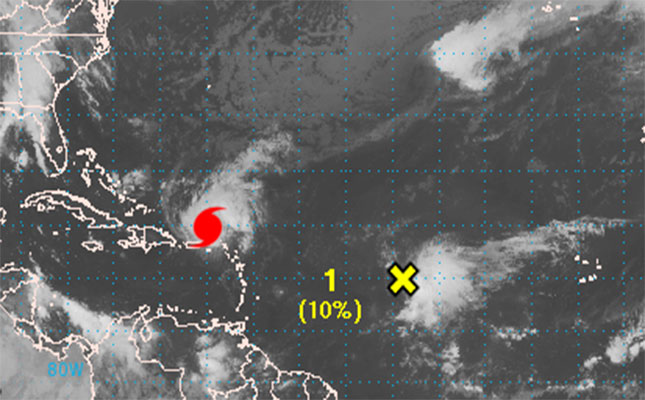
BASSETERRE, St. Kitts (Oct. 14, 2014 9:40a.m.) - HURRICANE GONZALO has passed through the Leeward Islands and now has its eye set on Puerto Rico.
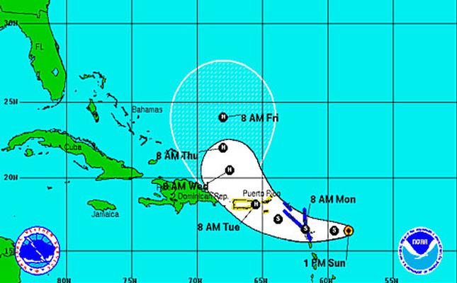
According to the National Oceanic and Atmospheric Administration’s National Hurricane Centre (NHC), Hurricane Gonzalo, with maximum sustained winds of 110mph, is now "a strong Category Two hurricane" and is moving away from the US Virgin Islands.
Information received from the St. Kitts Met Office indicates that at about 8:00a.m. today (Oct. 14) Hurricane Gonzalo was located some 200 miles to the north of St. Kitts and Nevis.
The tropical storm and flash flood warnings that were in effect for the Federation have been lifted.
(Oct. 13, 2014 7:40p.m.) – WITH maximum sustained winds of 75mph, Tropical Storm Gonzalo has been upgraded to hurricane status.
A recent St. Kitts Met Office advisory indicates that the system is moving in a north-westerly direction at 12mph and continues to move further away from St. Kitts and Nevis.
However, "skies will be cloudy to overcast tonight with showers or rain and thunderstorms" and "a flash flood warning has been extended until midnight
(Oct. 13, 2014 9:40a.m.) - TROPICAL STORM GONZALO has begun affecting the Leeward Islands but because its rate of movement has slowed, its impact would continue to be felt during the course of the day, the St. Kitts Meteorology Office has indicated.
An advisory which it issued this morning (Oct. 13) indicates that at about 5:00a.m., the system was located 16.8N, 60.9W or about 90 miles east-south-east of St. Kitts and Nevis and about 65 miles east-south-east of Antigua.
The tropical storm watch status of Puerto Rico, Vieques, Culebra, the US Virgin Islands and the British Virgin Islands has been updated to a hurricane watch as TS Gonzalo is expected to strengthen into a hurricane by Tuesday evening.
A tropical storm warning remains in effect for Guadeloupe, Desirade, Les Saintes, Marie Galante, St. Martin, St. Barthelemy, St. Maarten, Saba, St. Eustatius, Antigua and Barbuda, Anguilla and Montserrat.
Maximum sustained winds have increased from 40 mph to near 60 mph.
A flash flood warning was issued yesterday and is reportedly still in effect.
Weather conditions have prompted the closure of most government offices as schools as well as some private sectors companies.
Residents of and visitors to the Federation are advised to closely monitor the media for updates on TS Gonzalo.
(Oct. 12, 2014 p.m.) THE Federation of St. Christopher and Nevis is among several Caribbean territories that have been placed under tropical storm warning with the recent development of Tropical Storm Gonzalo in the Atlantic Ocean.
The system, according to an advisory issued by the St. Kitts Meteorology Office today (Oct. 12), indicates that at about 1:30p.m., TS Gonzalo was located at approximately 290 miles east-south-east of the Federation and about 200 miles to the east of Guadeloupe (16.4N, 58.4W).
The system has maximum sustained winds of 40 miles per hour (mph) and currently moves westward at about 10 mph.
Tropical Storm warnings are in effect for Guadeloupe, Desirade, Les Saintes, Marie Galante, St. Martin, St. Barthelemy, St. Maarten, Saba, St. Eustatius, Antigua and Barbuda, Anguilla and Montserrat while a tropical storm watch is in effect for Puerto Rico, Vieques, Culebra, the US Virgin Islands and the British Virgin Islands.
The advisory also suggests that TS Gonzalo is expected to “move through the Leeward Islands by early Monday morning and is expected to either pass directly over the group or just to the north.
Tropical storm-force winds “extend outward up to 45 miles (or) 75 km” and some strengthening is expected to take place over the next 48 hours.
With as much as eight inches of rainfall expected to be dumped across the Leeward Islands, individuals are being advised to avoid watercourses as these might become hazardous during and after rainfall.