BASSETERRE, St. Kitts – THREE potential Tropical Storms are brewing in the Atlantic Ocean and forecasters are keeping a close watch.
According to the National Hurricane Center (NHC) predictions, two of the storms are in proximity of the Northern Caribbean.
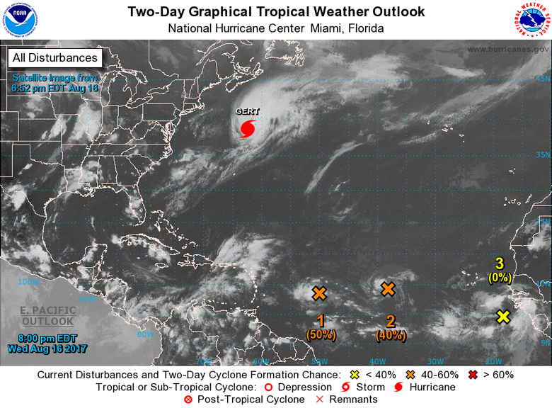
Firstly, they are looking at a low-pressure system located about 900 miles east of the Lesser Antilles, which continues to produce disorganized showers and a few thunderstorms. This system is moving westward at 15 to 20 mph, and it is expected to cross into the Caribbean Sea on Friday (Aug. 25).
“Upper-level winds are forecast to become a little more conducive for development during the next several days, and interests in the Lesser Antilles should monitor the progress of this system.”
However, they noted that the formation chance through 48 hours is low - 30 percent - while its chance through five days is medium to 40%.
That storm is expected to dump large amounts of rainfall which could dampen this weekend’s scheduled Caribbean Premier League games.
A second area of low pressure, which is located several hundred miles west of
the Cabo Verde Islands, is also said to be producing disorganized showers and
thunderstorms, according to the NHC.
The NHC is predicting the gradual development of this system, which they indicated is possible during the next few days before upper-level winds become less conducive over the weekend.
“This system is expected to move west-northwestward at 15 to 20 mph during the next several days. Formation chance through 48 hours...low...30 percent. Formation chance through 5 days...medium...40 percent.”
Meanwhile, a third tropical wave near the west coast of Africa is producing a
large area of disorganized showers and thunderstorms. Environmental conditions appear conducive for gradual development of this wave while it moves westward to west-northwestward at about 15 mph during the next several days.
Forecaster Berg of the NHC, who laid out the predictions, indicated that the formation chance for the tropical wave through 48 hours is low to near zero percent, while chance through five days is medium to 40%.
The St. Kitts Meteorological Services in a statement yesterday (Aug. 15) indicated that they are monitoring two areas of disturbance associated with low pressure areas in the mid-Atlantic Ocean.
“The closest one to the island chain is about 1200nm due east of the Leewards and is moving westerly at about 15mph to 20mph. The second system is further east at about 1800nm east of the Leewards and moving westerly to northwesterly at about 15-mph - 20mph,” the statement said..
According to the local forecasters, based on information analyzed at 3:00 p.m. yesterday (Aug. 15), the first system would be in the vicinity of the Leeward Islands by late Friday.
The statement suggested that early projections are for it to pass to the south of the Federation.
“It is too early to determine what impacts are likely if any at all but we at the St. Kitts Met Office will continue to monitor these areas of disturbed weather and provide updates throughout this week. As the systems are some distance away from the federation, some changes in their path and or potential impact are possible and as such updates will be provided daily until they passes the federation. Residents are therefore encouraged to continue listening out for official forecasts and bulletins from the St. Kitts Meteorological Services.”
The second system is expected to be in the vicinity of the islands by early next week.