WTNT32 KNHC 291455
TCPAT2
BULLETIN
HURRICANE EARL ADVISORY NUMBER 17
NWS TPC/NATIONAL HURRICANE CENTER MIAMI FL AL072010
1100 AM AST SUN AUG 29 2010
EARL EXPECTED TO STRENGTHEN AS IT HEADS TOWARD THE NORTHERN
LEEWARD ISLANDS
SUMMARY OF 1100 AM AST 1500 UTC INFORMATION
-----------------------------------------------
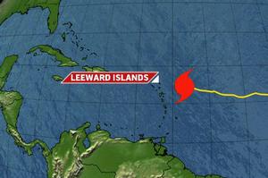
LOCATION...17.2N 58.4W
ABOUT 225 MI...360 KM E OF ANTIGUA
ABOUT 315 MI...510 KM E OF ST. MARTIN
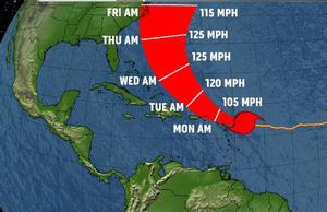
MAXIMUM SUSTAINED WINDS...75 MPH...120 KM/HR
PRESENT MOVEMENT...W OR 280 DEGREES AT 17 MPH...28 KM/HR
MINIMUM CENTRAL PRESSURE...985 MB...29.09 INCHES
WATCHES AND WARNINGS
--------------------
CHANGES WITH THIS ADVISORY
A tropical storm warning has been issued for the U.S. Virgin islands and Puerto Rico including the islands of Culebra and Vieques. A hurricane watch is also in effect for these areas.
Summary of watches and warnings in effect:
A hurricane warning is in effect for...
*Antigua andBarbuda,Montserrat,St. Kitts-Nevis and Anguilla
* Saint Martin and Saint Barthelemy
* St. Maarten,Saba and St. Eustatius
A hurricane watch is in effect for
* British Virgin Islands
* U.S. Virgin islands
* Puerto Rico including the islands of Culebra and Vieques
A tropical storm warning is in effect for
* British Virgin Islands
* U.S. Virgin Islands
* Puerto rico including the islands of Culebra and Vieques
Hurricane conditions are expected within the hurricane warning area within the next 24 hours. Preparations to protect life and property should be rushed to completion.Hurricane conditions are possible within the watch area within the next 36 hours.
A tropical storm warning means that tropical storm conditions are expected within the tropical storm warning area within 36 hours.
For storm information specific to your area in the United States including possible inland watches and warnings please
monitor products issued by your local national weather service forecast office. For storm information specific to your area outside
the United States, please monitor products issued by your national meteorological service.
Discussion and 48-hour outlook
------------------------------
at 1100 am ast...1500 UTC the center of hurricane earl was located near latitude 17.2 north longitude 58.4 west. Earl is moving toward the west near 17 mph 28 km/hr. A turn toward the west-northwest with a gradual decrease in forward speed is expected during the next day or so. On the forecast track the center of earl will pass near or over the northern Leeward Islands tonight and Monday.
Maximum sustained winds are near 75 mph 120 km/hrwith higher gusts. Earl is a category one hurricane on the saffir-simpson hurricane wind scale. Strengthening is expected during the next 48 hours and earl is forecast to become a major hurricane by Tuesday.
Hurricane force winds extend outward up to 30 miles 45 km from the center and tropical storm force winds extend outward up to 160 miles 260 km.
The latest minimum central pressure reported by air force hurricane
hunter aircraft is 985 mb...29.09 inches.
Hazards affecting land
----------------------
Wind, tropical storm conditions are expected in the warning area later today with hurricane conditions expected by early Monday morning. Tropical storm conditions are expected to spread over theVirgin Islands and Puerto Rico on Monday with hurricane conditions possible Monday night.
Storm surge: storm surge will raise water levels by as much as 1 to 3 feet above ground level primarily near the coast in areas of
onshore wind within the warning area. The surge will be accompanied by large and dangerous battering waves.
Rainfall: Earl is expected to produce total rainfall accumulations of 3 to 5 inches over much of the northern Leeward Islands with
possible isolated maximum amounts of 8 inches. Earl is expected to produce total rain accumulations of 4 to 6 inches over Puerto Rico with isolated maximum amounts of 12 inches possible over higher elevations. These rains could cause life-threatening flash floods and mudslides.
Next advisory
-------------
Next intermediate advisory...200 pm ast.
Next complete advisory...500 pm ast.

-13090_ACTIF2025_St.George's_Grenada_Ad_13x10.3125in_3 (1).jpg)