BASSETERRE, St. Kitts – THE Caribbean is keeping a close eye on the third tropical storm to form for the 2013 Atlantic Hurricane Season, TS Chantal, which has the Lesser Antilles in its sight.
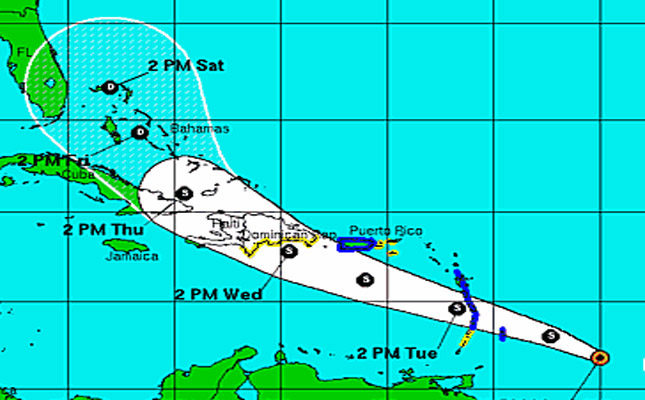
A National Hurricane Center report placed the centre of the system at 11.8N and 53.9W or approximately 390 miles to the east-south-east of Barbados at 5:00 p.m. today (Jul. 8).
It is moving at a speed of 26 mph and is making a west-north-west motion towards land.
In preparation for TS Chantal’s landfall, a tropical storm warning has been effected for Barbados, Dominica, St. Lucia, Martinique, Guadeloupe and Puerto Rico, while a tropical storm watch is in effect for St. Vincent, The US Virgin Islands, Vieques and Culebra and the southern coast of the Dominican Republic from Cabo Engano westward to the Dominica Republic-Haiti border.
The NHC reports that the west-north-westerly trajectory is expected to continue for the next couple of days and it predicts that “the centre of Chantal should reach the Lesser Antilles early tomorrow, move into the Eastern Caribbean Sea later in the day and be near the Dominican Republic on Wednesday.
“Tropical storm conditions are expected to reach portions of the Windward Islands on Tuesday and reach Puerto Rico on Wednesday. Tropical storm conditions are possible in the Dominican Republic by late Wednesday.”
Although the advisory doesn’t speak specifically to the Federation of St. Kitts and Nevis, a statement issued by the National Emergency Management Agency (NEMA) has informed that according to the experts, “St. Kitts and Nevis could experience moderate to heavy showers and thunderstorms occasionally, possibly beginning from mid-morning on Tuesday (July 9) into Wednesday (July 10).”
It is advised therefore that residents monitor local radio stations and other media outlets for additional information on the weather system. Further advice is that persons should avoid parking their vehicles in ghauts and other areas which have been identified as watercourses.